Systemic racism pervades the very air we breathe, the water we drink, and the land we inhabit. We’ve created two separate rides that explore the theme, and the damage that environmental racism causes. One ride is within the city of New Orleans; the other travels upriver and explores the fence-line communities of Cancer Alley.
Route A: New Orleans East and Desire[su_spoiler title=” Click here to see suggested turn-by-turn directions and stop info for this 23 mile route. ” open=”no” style=”default” icon=”plus” anchor=”” class=””]
Turn by turn directions can be found here: https://goo.gl/maps/Bw34Lt9FC9Qf9oyEA
Stop 1: Milneburg Lighthouse[su_expand height = “50”]This would have been the location of Pontchartrain Beach Amusement Park in the 1930s. Pontchartrain was a beach and park that remained “whites only” until the Civil Rights Act of 1964 integrated public spaces by law. Meanwhile, Black citizens of New Orleans were forced farther and farther east for lakefront access after being banned from accessing West End, Milneburg, and Seabrook.
This area and its surrounding neighborhoods continue to be some of the wealthiest in the city.
[/su_expand]
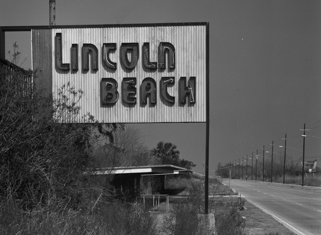
Stop 2: Lincoln Beach[su_expand height = “50”]In 1938 this little-developed area near Little Woods was sold to the city by Sam Zemurray, owner of the United Fruit Company. The New Orleans Levee Board purchased the land in order to build a “separate but equal” recreational area for the Black community of New Orleans. The two swimming areas were decidedly unequal, and unlike its easily accessible whites-only counterpart, Lincoln Beach was not served by a streetcar line, and was in an area of the lake polluted by sewage and filled with reptiles. The levee walls and imported white sand that created the Milneburg/Pontchartrain Beach area (as well as development of other parts of the lakefront) also caused problems for Black swimmers, causing erosion and unsafe swimming conditions for the areas surrounding Lincoln Beach.
In 1953, the New Orleans Levee Board committed to building a new park at Lincoln Beach, which the city assured residents would be better equipped than the original 1939 site. Once completed, though, the new park was still smaller and viewed as inferior compared to Pontchartrain Beach. After desegregation in 1964, attendance at Lincoln Beach declined rapidly, and eventually the park closed the following year. Although there have been various proposals to redevelop the Lincoln Beach area, the decaying ruins of the park have remained vacant for decades. The city of New Orleans has recently begun to consider efforts to clean-up and re-open the area, and so this is a space whose future is very much an open question.
[/su_expand]
Stop 3: Gordon Plaza[su_expand height = “50”]The Robert R. Morton Elementary School, now abandoned, once served as the elementary school for residents of Gordon Plaza and Desire neighborhoods. Opened in 1987, the school and its surrounding subdivision were built on the former site of the Agriculture Street Landfill. This landfill is where the city’s toxic waste had been dumped for over 50 years. Reports in 1993 by the Environmental Protection Agency (EPA) declared Gordon Plaza a superfund site.
Today, Gordon Plaza residents are demanding that the city of New Orleans fully fund their relocation, pointing to well-documented problems with pollution at the site, despite a contentious (and seemingly ineffective) 1997 EPA clean-up effort. Residents say the lethal environment has caused buildings to be permanently shut down, minor illnesses, and terminal health issues. An April report from the Louisiana Tumor Registry found that Gordon Plaza and the surrounding Desire neighborhood had the second highest cancer rates in Louisiana from 2005-2015. Supported by the New Orleans Peoples Assembly, Gordon Plaza residents continue to fight for a fully funded relocation of their homes. Mayor Cantrell has communicated her willingness to finding a “solution” for residents, but the city has yet to commit to concrete actions. This struggle is ongoing; learn more at the online exhibition “The American Dream Denied,” or visit www.peoplesassemblyneworleans.org/gordon-plaza.
[/su_expand]
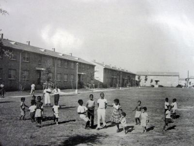
Stop 4: Desire Neighborhood[su_expand height = “50”]Once a humble but thriving African American community, the Desire neighborhood was destroyed in the late 1940s to build the largest housing development in New Orleans. Completed in 1956, the Desire Projects – like Gordon Plaza – were built on the site of a former landfill. Six weeks before the housing units were finished and residents moved into the complexes, the Tenants’ Association declared that the new construction was “unsafe for human habitation.”
In August 1970, Mayor Moon Landrieu sent his “special assistant” Robert H. Tucker, Jr. to spend seventy-two hours in the Desire Projects, and to report on the living conditions there. Tucker’s report was clear: “Life in any multi-family structure for the low income family is a very difficult proposition to say the least. The Desire housing project is a classic study of the worst,” he wrote, describing children wading through clogged sewers, families frightened by robberies and assaults, garbage that went uncollected for days or weeks, and an explosive atmosphere of isolation and poverty. (Tucker, who grew up in New Orleans, came to the Landrieu administration as an activist, having participated in lunch counter sit-ins while attending college in Atlanta, helped integrate the National Park Service as one of the first Black park rangers, and eventually returned to his home town). After Tucker’s report, the Desire became known as one of the worst public housing projects ever put into place. Living conditions continued to deteriorate, until the city finally began the process of tearing down Desire in 1995.
Despite its reputation, it is important to remember that Desire was also a largely self-contained community, filled with thousands of people and their rich, textured lives. Reflecting on the neighborhood where he grew up, former resident Dan Perkins told WWNO, “We made fun. We found pleasure. You know we were determined to have a desire to be where we were. We had no other choice. And we made our own pleasure and you know we found out that we were human just like like everybody else. They always say no good thing came outta this project, but they were wrong.”
In 1970, the Black Panther Party established a New Orleans headquarters in the Desire Projects, quickly setting up a variety of social programs such as meal & health assistance, political education, and self defense classes to assist the residents of Desire. Throughout 1970, with the love and support of the community, the Panthers would survive an eviction, and then a September 15th shoot-out with local, state, and federal law enforcement agents. As a result of the shoot-out, a dozen Panthers were charged with the attempted murder of five New Orleans police officers, but in August 1971 a jury acquitted the Panthers after only a half hour of deliberation. Shortly after the verdict, both of the Panther headquarters in the neighborhood were “mysteriously” burned down by “parties unknown.”
[/su_expand]
[/su_spoiler]
Route B: Audubon Park to the Spillway[su_spoiler title=” Click here to see suggested turn-by-turn directions and stop info for this 52 mile route. ” open=”no” style=”default” icon=”plus” anchor=”” class=””]
Turn by turn directions can be found here: https://goo.gl/maps/z1iRnGy85k4RtxbGA
Stop 1: Shell Norco & the Diamond community[su_expand height = “50”]In the early 1950s, Shell purchased land in the community of Diamond, Louisiana, and built a chemical plant. A small subdivision, Diamond was home to most of the Black population living in Norco at the time. A pipeline explosion in 1973 that killed two Diamond residents, while another event in 1988 killed seven workers. Finally, in 1989 Margie Richard, a resident of Diamond, founded Concerned Citizens of Norco (CCN) after two large-scale accidents at the Shell/Motiva Chemical plant. CCN’s goal was for Shell Chemical to fund the relocation of Diamond families by purchasing homes at market value. However, until 2001 Shell was purchasing homes in Diamond for around $27,000, a fraction of the price that houses only a few blocks away were selling for. Finally, on June 11th, 2002, and under continued pressure from CCN, the EPA, and the Louisiana Bucket Brigade, Shell agreed to buyout Diamond.
Neighborhoods that are immediately adjacent to industrial plants, and are directly affected by the noise, odors, chemical emissions, and operations of those plants exist all along an 85 mile stretch of the Mississippi River between New Orleans and Baton Rouge, also known as Cancer Alley. The Louisiana Bucket Brigade continues to advocate for the residents of these “fence-line” communities. For twenty years, they have provided technical support in the areas of media, air monitoring, organizing, cartography, accident research, and report writing. Visit https://labucketbrigade.org/ to learn more.
[/su_expand]
Stop 2: Kugler and Kenner Cemeteries[su_expand height = “50”]Construction of the Bonnet Carré Spillway destroyed two cemeteries dating back to the 1800s that held the remains of enslaved African Americans and their descendants. Since then, the burial sites have earned proper designation and a place on the National Register of Historic Places. There are no markers for the cemeteries themselves, although the Army Corps of Engineers has tentative plans to eventually create monuments to the people who lived and died in this area.
Read more about the cemeteries in Robin McDowell’s piece for Antigravity, “Sacred Ground: Unearthing Buried History at the Bonnet Carré Spillway.”


[/su_expand]
[/su_spoiler]
While you are riding, bring masks and hand sanitizer, respect physical distancing, and make sure that you have an emergency contact who knows where you are and can pick you up if needed. We also have some more in-depth tips for safe biking in the pandemic, check them out! Please be aware that NOLA to Angola cannot provide logistical or emergency support to individual riders this year. Take care, and safe riding!